To get down to the coast in this part of the world, one runs down to the town of Kaplan and then takes a left onto the road, beside a large rice mill. The road continues past various dwellings and a nasty looking chemical plant as one progresses towards the coast. In July, this run was spectacular and green. Of course, the weather was also disgustingly hot. At first, the land looked much the same as it did, although wearing the mantle of what passes for Winter in this part of the world. Then we began to see the effects of the storm. Actually, what we noticed first was not the effect of the wind, but rather the result of the storm surge. As Hurricane Rita hit the coast of Louisiana it forced salt water from the Gulf of Mexico onto the land. To put it mildly, salt water is not very good for the vegetation.
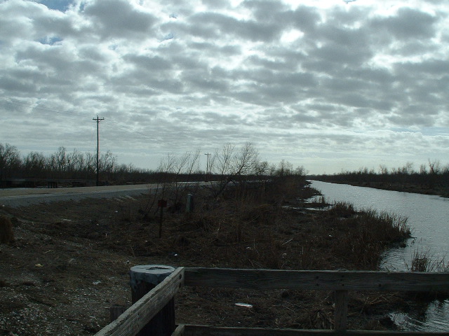
There is a stretch of road one comes across as one heads South that is totally straight, with water each side. In July, verdant green bushes and small trees stretched as far as the eye could see. At various points along this stretch of road there are wooden stands for fishing. We stopped at one of these. We did this in July too. The one we stopped at then smelled bad, had a bag of empty beer cans attached to it, along with some racist graffiti. This time, we choose to stop at another. The difference, due to the storm surge, not the choice of stand, was dramatic. This was also the first opportunity to take some photos.

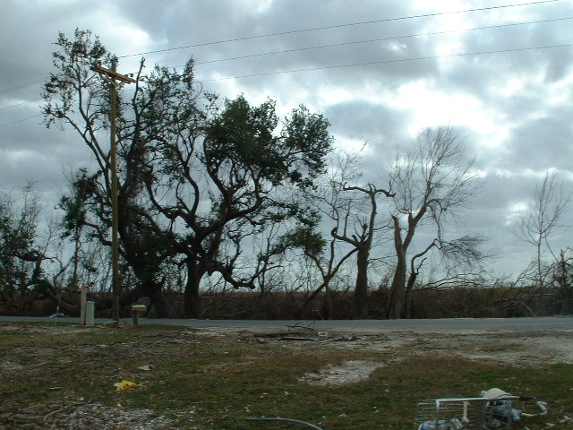
Clearly, the tree to the left has seen better days. (N.B. with all images on this page, if you click on them with your mouse, you can see a larger version). The view behind it is also telling. In July, the view was blocked by tall boughs of green. Now, they are all gone.
The next picture (to the right) gives an impression of the utter devastation to the plant life. It also shows the edge of the fishing stand, the canal and the road.
 What was once
amazingly full of green life has been transformed into utter desolation
by the salt water in the storm surge. Although these pictures are nice
enough, they totally fail to convey the massive and horrific
transformation. I really wish I had taken pictures in July, so as to be
able to illustrate the change.
What was once
amazingly full of green life has been transformed into utter desolation
by the salt water in the storm surge. Although these pictures are nice
enough, they totally fail to convey the massive and horrific
transformation. I really wish I had taken pictures in July, so as to be
able to illustrate the change. It is worth remembering that in this part of the world, Vermilion Parish, one of the main economic activities is agriculture. If you had cattle, do you think that they could live off this vegetation? I think not.
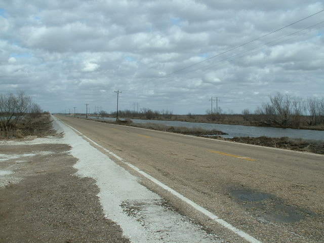
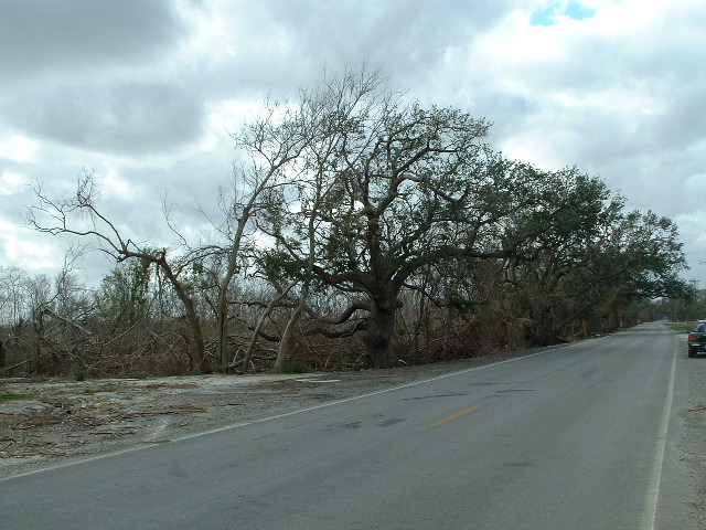
The next picture, to the left, illustrates the desolate vista along the road. You have to imagine how this used to look -- it was so green. Now, to put it mildly, it isn't. This picture also illustrates a feature of the way that this road was constructed. The white along the edge is seashells. The way this road was built was by the piling up of dredged sediments. These sediments contain many shells. It is also worth remarking that the construction of the road is worth praise. It clearly must have survived a lot.
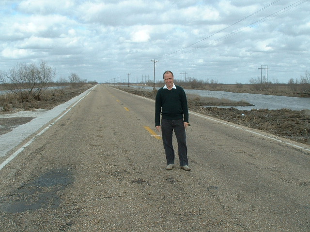
In the next picture, my colleague Jon gives some scale to the vista by standing in the middle of the road. Highway 82 was probably never the busiest road in the world. However, given that this is the main road to several communities, this conveys an impression of just how empty this part of the World has become. Try this on the main road to many communities and one's life insurance people would not be amused!
 To the left is
another picture that illustrates how much damage the storm serge did.
When here in July, there were verdant bushes that were taller than most
humans. They have been scoured away by the storms. Goodness knows where
all the vegetation ended up. Now what is left looks like the kind of
place that would be appropriate as a set for filming the next Mad Max
film.
To the left is
another picture that illustrates how much damage the storm serge did.
When here in July, there were verdant bushes that were taller than most
humans. They have been scoured away by the storms. Goodness knows where
all the vegetation ended up. Now what is left looks like the kind of
place that would be appropriate as a set for filming the next Mad Max
film.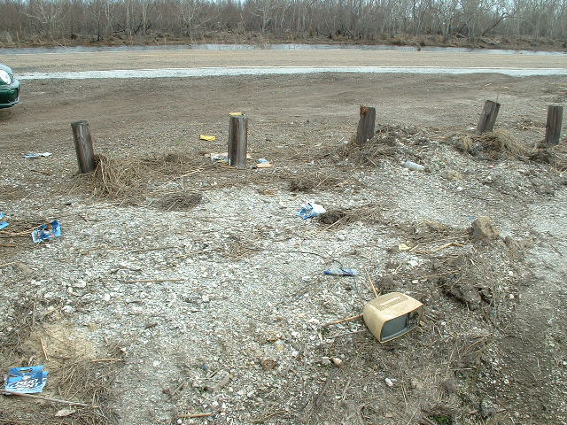
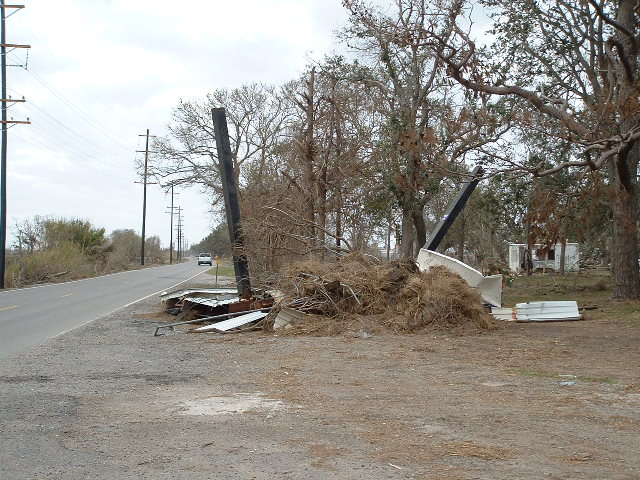
The final two pictures taken at this location illustrate the debris that was swept along by the water. The picture to the right shows various bits of detris, along with a rather lost and forlorn television. At the top of the picture, one can catch a glimpse of the canal on the other side of the road. The dead bushes are also visible.
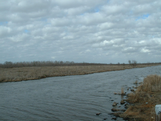
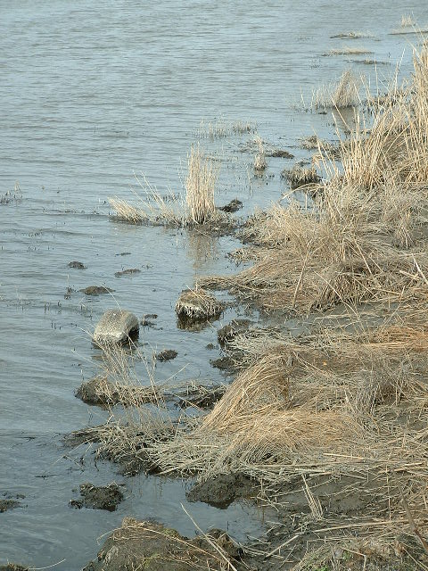 Perhaps
the most amazing thing about this area is the appearance of all the
dead plants. In the picture to the left, the grass looks like it might
have just died from lack of water. However, the proximity to the canal
water makes it clear that this is not the case. It is the deadly
effects of the salt water from the Gulf of Mexico, brought inland by
the storm that is responsible for the current situation. The tire that
can be seen in this picture may be a hurricane artifact, or it may have
been abandoned here before the storm.
Perhaps
the most amazing thing about this area is the appearance of all the
dead plants. In the picture to the left, the grass looks like it might
have just died from lack of water. However, the proximity to the canal
water makes it clear that this is not the case. It is the deadly
effects of the salt water from the Gulf of Mexico, brought inland by
the storm that is responsible for the current situation. The tire that
can be seen in this picture may be a hurricane artifact, or it may have
been abandoned here before the storm.Although the effects of the tempests on this stretch of road are clearly dramatic, they did not prepare us for what we were to come across a few miles further on. After driving a bit further, we began to get to some of the coastal communities. Seeing what had happened there really brought home just how powerful the effects of high winds and high water can be.
The next place we stopped was the small community of Pecan Island. We had also stopped there in July. Then, we managed to buy lunch in a small grocery store.
 The
lady who ran the store was very friendly. She said that she was
originally from the town of Deridder, but had lived down on the coast
for 30+ years and really loved it.
The
lady who ran the store was very friendly. She said that she was
originally from the town of Deridder, but had lived down on the coast
for 30+ years and really loved it.  Initially
when we stopped this time, I was not sure that we were actually in the
same place. The pictures left and right show the remains of
the
building that was the store, I think. The amount of very ordinary every
day stuff spread around was dramatic. There were video tapes and a
computer alone on its side in the middle of an otherwise clear patch of
ground.
Initially
when we stopped this time, I was not sure that we were actually in the
same place. The pictures left and right show the remains of
the
building that was the store, I think. The amount of very ordinary every
day stuff spread around was dramatic. There were video tapes and a
computer alone on its side in the middle of an otherwise clear patch of
ground. 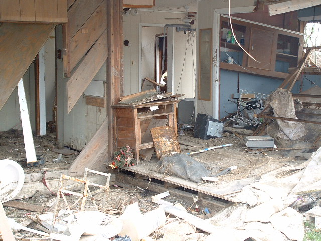
The side of the building was entirely missing. The picture to the right illustrates this. The small Christmas tree in the middle of the picture is emblematic of the lives abruptly interrupted and changed forever. One of the things that the pictures do not properly convey is the distance the building had been moved. The concrete slab that the building had originally rested upon was about twenty feet in front of the current location of the structure.
 The
next two pictures show the view from this location when looking
Southward towards the Gulf of Mexico. In July, this was a dense copse
of trees. We ate out lunch in the sweltering heat shaded by the tree
visible in the picture on the right. In fact, it was only due to
recognizing the shape of this tree that finally convinced me that this
really was the location of the store, so complete was the devastation
and transformation wrought by the storm. It appears that this tree is
one of the few that have survived the tempest relatively
intact.
Quite where the others have gone is a mystery.
The
next two pictures show the view from this location when looking
Southward towards the Gulf of Mexico. In July, this was a dense copse
of trees. We ate out lunch in the sweltering heat shaded by the tree
visible in the picture on the right. In fact, it was only due to
recognizing the shape of this tree that finally convinced me that this
really was the location of the store, so complete was the devastation
and transformation wrought by the storm. It appears that this tree is
one of the few that have survived the tempest relatively
intact.
Quite where the others have gone is a mystery.One of the things that is a little bit tricky about a journey like the one being described is how to document the situation, without intruding upon the privacy of the people of the communities being passed though. The policy adopted here was to only stop and take pictures where
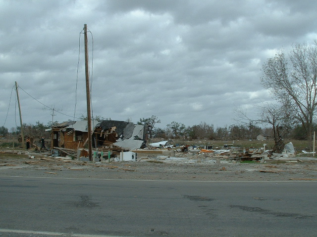
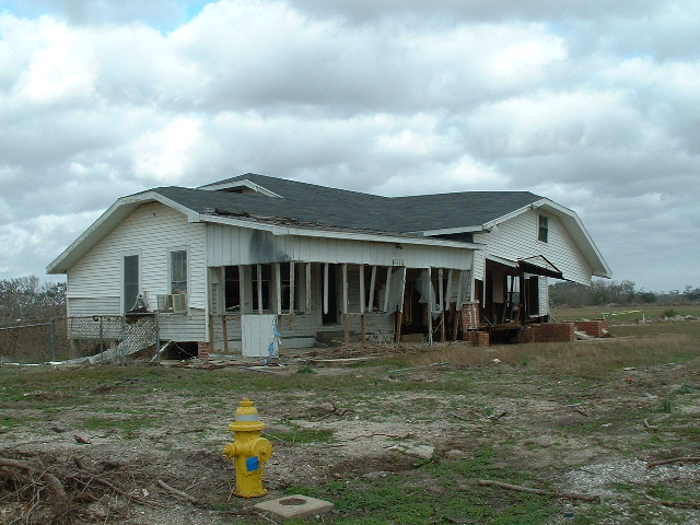 there
not people around. A consequence of this choice is that there are
significant lacuna in the pictorial record here. However, to the left
is a picture of a damaged house that conveys an impression of the kind
of devastation that was common.
there
not people around. A consequence of this choice is that there are
significant lacuna in the pictorial record here. However, to the left
is a picture of a damaged house that conveys an impression of the kind
of devastation that was common.After leaving Pecan Island, there was another stretch of open road to be negotiated as we drove towards Cameron Parish. By and large, the road had survived the storm fairly well, but this was not always the case. In many areas, the shoulder of the road had been entirely washed away. Indeed, in one section, it looked as if some large animal had taken small bites out of the road itself. In one location, the damage top the road was sufficiently extreme that the intelligent way to drive seemed to be straight down the middle of the road, so as to avoid any weaknesses in the road surface.
As we approached the Cameron Parish border, there were signs that indicated that there may be a check point and further road problems.
 We
prepared ourselves to return the way we had come, should it prove
impossible to get through. As it happened, there was no check point and
only the occasional set of road works. Thus, we were able to
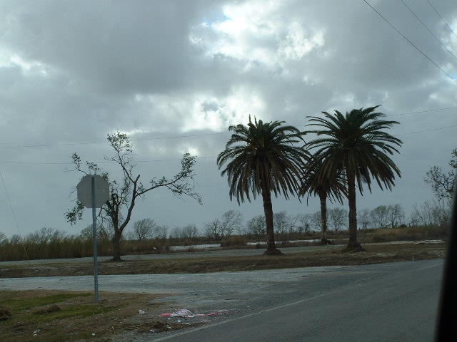
drive
along the coast line, through the devastation towards the town of Grand
Chenier. The photo to the right shows two palm trees that had some how
survived the storm intact, along this stretch of road. The Gulf of
Mexico is not quite visible behind the trees.
We
prepared ourselves to return the way we had come, should it prove
impossible to get through. As it happened, there was no check point and
only the occasional set of road works. Thus, we were able to
drive
along the coast line, through the devastation towards the town of Grand
Chenier. The photo to the right shows two palm trees that had some how
survived the storm intact, along this stretch of road. The Gulf of
Mexico is not quite visible behind the trees.When visiting Grand Chenier in July, we stopped at a gas station to buy cold drinks and to take a pee. It was a nice little place, with friendly, chatty people. Behind the counter, one could see the bills of various local people. Clearly, this was a place where people trusted one another.
 Quite alot had changed. The picture to
the left shows what is left of the large sign. The view looking back
towards where the store and the pumps had been is illustrated
to the right.
Quite alot had changed. The picture to
the left shows what is left of the large sign. The view looking back
towards where the store and the pumps had been is illustrated
to the right. 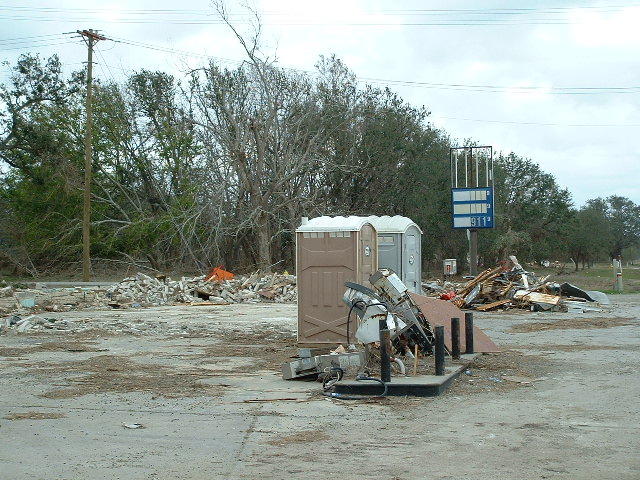 Where the building had stood was just a
concrete slab, with debris. There is very little left of the pumps
either. There was also a canopy here, but goodness knows where that had
ended up. The one addition since the storm was a pair of 'portalets'.
With the facilities of the store gone, these were a welcome facility!
Where the building had stood was just a
concrete slab, with debris. There is very little left of the pumps
either. There was also a canopy here, but goodness knows where that had
ended up. The one addition since the storm was a pair of 'portalets'.
With the facilities of the store gone, these were a welcome facility! Of all the places on this journey, Grand Chernier appeared to be the most devastated. What had once been the brick built Middle School is now only a few bricks tall -- it is utterly gone. Another thing that was quite shocking was the number of signs indicating where churches had once stood. Although the signs had survived, the only evidence of the churches was all too often just a concrete slab.

To the right is an image taken of the remains of a residence in Grand Chernier. It is clear that it will not be habitable again. Yet, there we also saw people working to rebuild. People were even living in tents in order to get the job done.
Although this part of Louisiana lacks the name recognition of New Orleans and is probably sufficiently far off the beaten track to attract little media attention, hopefully these images will convey the extent of the tragedy caused by Hurricane Rita. These people have seen devastation as bad, or worse as the devastation that makes the news. They deserve as much help as the next victim of the deadly storms of 2005.
As we got to where the road was blocked by debris, before the town of Cameron we passed the town of Creole. This too was an utter mess. However, as we followed the road as it turned North from there, there were two more amazing sights. One was a boat in a canal
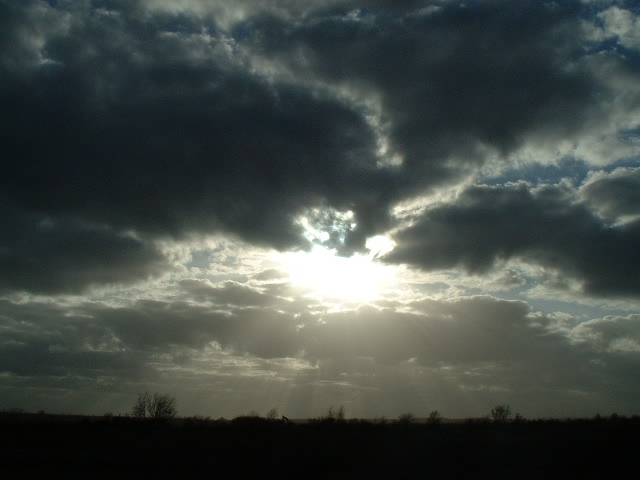 that ran beside the road. Now, on the
face of it, a boat in a canal is nothing too exceptional. However, what
made this boat different was the fact that it was standing vertically
upright, with the prow of the boat embedded into the bed of the canal.
Unfortunately, it was not possible to get a photo of this. The second
amazing sight was the cloudscape pictured to the right.
that ran beside the road. Now, on the
face of it, a boat in a canal is nothing too exceptional. However, what
made this boat different was the fact that it was standing vertically
upright, with the prow of the boat embedded into the bed of the canal.
Unfortunately, it was not possible to get a photo of this. The second
amazing sight was the cloudscape pictured to the right. Let us hope that the 2006 hurricane season is kinder to Louisiana and the Gulf coast. Also, whoever reads this, should you be able to do anything to help the people of coastal Louisiana, where the television cameras seldom roam, then please do what you can to help. It will be appreciated by some very wonderful people.
(c)
All text and images are copyrighted to Dr. Istvan S. N. Berkeley, 2006.
Please send all comments and corrections to istvan@louisiana.edu.